It’s a bird. It’s a plane. Or, it’s a new technology for surveying land.
Drones have been hitting construction sites everywhere, with efficiency and accuracy that are compelling to even the most technology averse. As drones gain popularity, builders and developers are considering their worth. In an article from Fortune last year, the many benefits of drone use were outlined.
For builders, the case for return on investment is straightforward. Drones are cheaper to fly than manned aircraft and faster than human surveyors, and they collect data far more frequently than either, letting construction workers track a site’s progress with a degree of accuracy previously unknown in the industry. With the right computing tools, builders can turn sensor data into 3D structural models, topographical maps, and volumetric measurements (useful for monitoring stockpiles of costly resources like sand and gravel). Collectively, that intelligence allows construction companies to more efficiently deploy resources around a job site, minimize potential issues, trim costs, and limit delays.
Bob Hawksley, CEO at Fischer Homes a Kentucky-based builder with 8,200 lots, recently put drones to the test. He started his strategy for using drones by putting a team together last year, which included Christopher Niven, director, special projects, and Adam Clouse, site design project manager.
The team decided it needed to do a controlled experiment. It started with two communities to show how traditional surveying compared with drones. The proof was inspiring and a testament to embracing technology. One person flew the drone from the field on the 38 acres in an hour and a half, plus some time plotting the ground control points (GCPs), and 17 unmanned hours were spent processing the images with specialized computer software.
That’s all well and good but how does that compare to a traditional survey process? Typically, Fischer subcontractors use a survey crew with two people, and the process for capturing the same development would take one full day in addition to the time and unknowns in arranging a schedule for the survey crew to do its work.
Proving Accuracy
The Fischer Homes team’s experimentation continued. As Niven and Clouse explained it, the drone flies a grid and takes a bunch of pictures as it’s going. The pictures have to be vetted to make sure that they match each other, all based on GCPs that were pre-selected. And the software digests the images and converts them, which is the process that took 17 hours for the 38-acre development.
In these pictures, every pixel has a z-value, or a terrain value, with a physical coordinate and all measurements that would normally be captured during the survey process. From the picture, there are two products: the raw data that is way too large and at this point not useful to Fischer Homes, along with the digital terrain model that has the z-value on every one-third of a foot.
After the 3D mapping of the drone captured survey data, it was compared with the “original grading plan.” During the pilot project, Niven found that they were within +/- 0.12 feet in accuracy to the conventional survey process with drone surveying at the GCPs. Other areas of the model are expected to hold larger amounts of error.
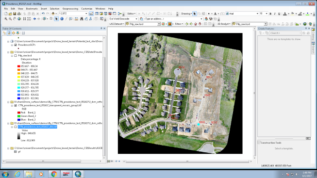
One aerial image identifies the 8 GCPs for this survey.
Niven points to the GCPs as the key to the accuracy. “If you just went out and flew it, it would give you a location, but it wouldn’t be accurate,” he says. “You need the reference points. We had eight for the 40 acres.”
Chris Anderson of 3D Robotics spoke to The Economist about the accuracy of using drones in construction.
Buildings are designed in a flawless digital environment but must be constructed in the much messier real world. “It’s all an information problem,” says Mr. Anderson. So the industry has been pursuing the idea of “reality capture,” using technology to measure buildings precisely during construction and track the use of raw materials on site to ensure that everything is going according to plan. Drones are ideally suited to the task. Thousands of aerial photographs are crunched into a 3D site model, accurate to within a few centimeters, called a “point cloud,” which can be compared with the digital model of the building.
This high level of accuracy leads to a wealth of benefits for Fischer Homes.
Fischer Homes purchased 10,000 lots in the downturn. Those lots came with different types of engineering, and no one had invested the time in doing as-builts in the field. As such, not everything on paper was in the field and vice versa. Currently, Fischer Homes finds it very costly to send a survey team to work on as-builts. Hawksley hopes to solve for that problem by marking some GCPs to calculate elevations from the survey team and then fly it with a drone to topographically map the surface and figure out, based on common points, whether it is accurate and done per plan. He also notes that every market has different ADA requirements and code compliances that are expensive and add to the cost of housing, but these also are easier to solve with drone surveying.
Hawksley says that typically his sales team has to set an expectation with customers based on a set of drawings. When, in reality, if it is not graded properly in the field, then it may not be accurate. The drone survey process removes the uncertainties, and buyers will get what they see in the drawings.
Hawksley also explains that the company has lots in developments with other builders. Some builders build their lots too high and it impacts the lots to both sides of that house. This drone survey will identify when and where that happens to address it before the build.
“We set top of foundation on every site, based on the plans,” Hawksley continues. “It would be good to confirm and get us to accuracy because 6 inches will make a difference with drainage.”
One of the other benefits he mentions is balancing dirt on each jobsite and not hauling it out, which can be a time consuming and expensive endeavor. By using drone surveying, the builder can tell if it was graded in accordance with the grading plan or not, which is especially important when the house is being built on a hillside. And although they are still figuring out the true value that drone surveying adds to this part of the process, Hawksley says, “We can save a couple of thousand dollars per home.”
Future Potential
While the cost and time savings are a great value proposition for using the drones now, there are future implications that make it even more beneficial in the near term. Fischer Homes envisions using the drones for marketing purposes and for interacting with buyers on a more frequent basis.
A drone could be used to survey before the build, after the grade, and then again after the home is built, Hawksley says.
A model that includes the terrain and the existing and proposed structures could resolve line-of-site issues for viewscape and communication concerns. Plus, in areas with significant terrain like Cincinnati, Clouse says it would facilitate defining where radio signals can move through and assist with setting up for Wi-Fi systems. They also point to benefits like getting a visual of landscaping and transformer locations.
With the company’s current number of lots and the short amount of time necessary to process those lots, Hawksley says there’s no need yet for a full-time drone operator. For now, he just wants to reap the basic savings and figure out what other benefits drone use could provide.
This story appears as it was originally published on our sister site www.hiveforhousing.com.